
Super Typhoon Bopha (Pablo) Affecting Davao Mindanao
|
Image Courtesy: Kochi University, Japan
|
 as it crossed the coast of Mindanao")
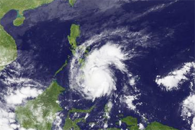
Super Typhoon Bopha (locally “Pablo”) made landfall around 6am (4th December, 2012) just South of Baganga town in the province of Davao Oriental. The expected track will take super typhoon Bopha across central and northern Mindanao to near Dipolog, Zamboanga del Norte, and then to Northern Palawan. What is unusual about super typhoon Bopha is that it has tracked so far South, for so long.
The weather system started as a tropical depression, some 1300 nautical miles East of Davao City, near 2.5N 159.0E, on the 25th November, as reported by the Joint Typhoon Warning Center and subsequently via the Puerto Galera Yacht Club email Typhoon Warning service. At that time, the storm system was expected to track west-northwest, with only a small chance of touching land in the Philippines.
By 27th November it was apparent that there was a high probability of it passing over southern Samar and, by 1st December, as a full typhoon, it was obvious that Mindanao would be the landfall . . . probably around Surigao City.
[Surigao City is no stranger to tropical storms although fully fledged typhoons are considered rare – the last one that caused significant damage in Surigao City was Typhoon Ike in 1984]
However, by 3rd December, super typhoon Bopha had set its sights farther South, and Surigao del Sur was considered the most likely target. Even then, keen typhoon watchers were expecting the storm to track farther South.
There is only one prior documented account of a typhoon passing over the northern extremes of Davao Cit,y and that occurred in almost the same week of the year (26-Nov through 1-Dec) in 1909. The 1909 typhoon formed south-southwest of Palau, entered Mindanao to the South of Caraga, passed north of Davao City proper, crossed the province of Cotabato and exited the island into the Sulu Sea South of Dapitan, Zamboanga del Norte.
Today, 4th December, at around 6am, super typhoon Bopha crossed the Mindanao coast, headed for Dapitan also. By 9am in Davao del Norte, the mountain town of Talaingod was reporting high winds and rain, with damage caused to plantations and flimsy wooden houses; New Corella was reporting similar destructive winds and rain, with landslides on denuded hillsides that have been recently converted from virgin rainforest to agricultural lands. In Davao City, the rain, which had been falling lightly since the previous evening, became heavy and the winds moderate to strong. Already, corrugated-iron roofs on houses in Davao City were being lifted, causing distress to occupants.
The forecast suggests that after exiting Mindanao near Dipolog, super typhoon Bopha is expected to cross the Sulu Sea, South of Tambobo Bay, Negros, and then on to northern Palawan, near Malampaya Sound, before passing into the West Philippine Sea and finally into the South China Sea.
I am frequently asked whether such extreme weather events are caused by Man-induced climate change. The fact that a similar typhoon passed over Mindanao, at a similar time of year in 1909, would suggest that the cause may not necessarily be related to climate change. However, the increased frequency of such extreme weather events – the last one, just one year ago, Severe Tropical Storm Washi (locally named “Sendong”), 15-18 December, 2011 – are, in my opinion, a clear result of warmer oceans, which in turn lead to more frequent severe weather events. Whatever the cause of the increased frequency of more severe storms, the increased devastation on land is definitely Man-induced – removing virgin rainforest, for timber and for conversion to agricultural land, is a most irresponsible act, as the now unchecked rainwater overwhelms & chokes waterways, and the topsoil-runoff in turn chokes vital coral reefs near river mouths.
Stay up to date on typhoon weather using the Puerto Galera Yacht Club Philippine Weather webpage